Term: right ascension (RA)
Right ascension is like longitude.
Longitude says how far the city is east or west along the Earth's
equator. The zero point of longitude has
been chosen to be where the line straight down from the Greenwich
Observatory in England meets the equator. So to measure right ascension
we need a zero-point; that zero point is called the vernal equinox.
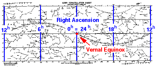
On the SC001 the vernal equinox has been placed at the center of the map.
Stars on the blue hour circle through the vernal equinox have right
ascension (RA) of 0h. As you move to the left (east!),
the RA increases finally reaching 12h at the far left hand side
of the map. Of course since the SC001 map is really part of a cylinder,
the far left hand edge is the same as the far right hand edge, and so you find
the far right hand blue hour circle is also labeled 12h. As you
continue moving left from the far right hand edge, RA continues to increase
reaching 18h, and finally 24h which is the same spot
at 0h.
Notice that while longitude is usually measured in degrees, we have a
new unit (h or hours) to report RAs. One hour of right ascension
(1h) is 15°. Since 24x15°=360°, there
are 24h of right ascension around the celestial equator.
The reason for this oddity is that the celestial sphere makes
one full rotation (24h of RA) in one day (24 hours of
time). Thus the celestial sphere advances about 1h of RA
in an hour of time. (FYI: the longitude here at CSB/SJU is about 95°W.)
NEXT