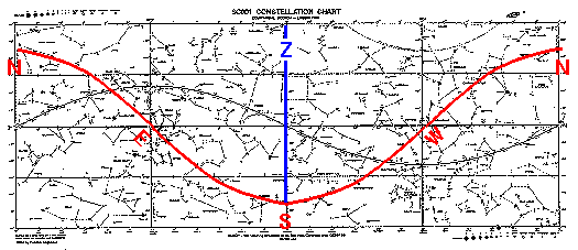
The most important "line" in astronomy is the observer's meridian. Since the meridian runs from pole to pole, it is part of a hour circle and hence a vertical line on the SC001. The blue line in the below image is the meridian (on, for example, March 21 at noon); the Z shows where zenith is.
Note that no stars below dec=-45° are above the horizon, and all stars above dec=+45° are above the horizon. I've explained why above. Note that the celestial equator directly meets the east and west points on the horizon. If you remember that the SC001 should be thought of as part of a cylinder (with right and left edges connected), you should be able to see that the horizon is a planer cut out of the cylinder.
If you were to travel north, the size of the circumpolar zone would increase and southern stars would have to be closer to the celestial equator to be visible. The horizon would approach the celestial equator. (In fact at the north pole, the NCP is at zenith the the celestial equator is the horizon.) If you were to travel south, the size of the circumpolar zone would decrease, and more southern stars could be seen. (In fact at the equator the celestial poles are on the horizon, and hence the horizon is an hour circle, which is a vertical line on the SC001.) Thus the "wavy" horizon becomes smoother as you go north, becoming flat at the north pole, and it becomes increasingly wavy as you go south, becoming vertical lines at the equator.