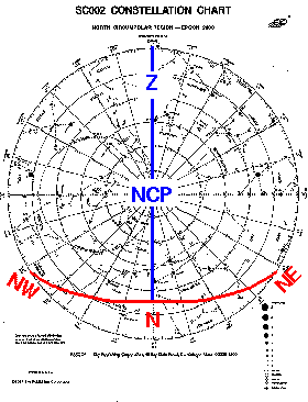
The most important "line" in astronomy is the observer's meridian. Since the meridian runs from pole to pole, it is part of a hour circle and hence a radial line on the SC002. The blue line in the below image is the meridian; the Z shows where zenith is.
Note that all the stars "above" dec=45° are above the horizon (i.e., are circumpolar), whereas some of the stars near the bottom edge are below the horizon now (and so have set). If you were to travel north, the size of the circumpolar zone would increase and and at a latitude of 60° all of the SC002 stars would be circumpolar. At the north pole, the NCP is at zenith. If you were to travel south, the size of the circumpolar zone would decrease, and the horizon would "eat into" the SC002. At the equator the north celestial pole sits on the horizon, and hence the horizon would become a line right through the center of the SC002.